

Short answer: to plan the Camino de Santiago by bike, don’t divide the total distance by the number of days you have. That’s the most common mistake. A cycling stage is measured by the metres of climbing and the type of terrain, not by distance: on the Camino Francés some 23 km days are harder than 65 km ones. The order that works is this: choose your route and starting point (by bike you need at least 200 km for the Compostela), decide how many days you have, split the stages by climbing, terrain and the towns where you want to stop, book accommodation that takes bikes, and sort out how you get there and back. And each Camino has its own priority: on the Primitivo it’s climbing, on the Portuguese it’s accommodation and on the Vía de la Plata it’s water and services. The Bicigrino route planner splits the stages using these criteria and, once you’re on the road, guides you from your phone.
Planning the Camino by bike is what people ask us about most before every season. We’ve been delivering bikes at the starting points for 20 years and we’ve seen which plans work and which don’t. This is what we’ve learned.
The most common mistake: planning by kilometres
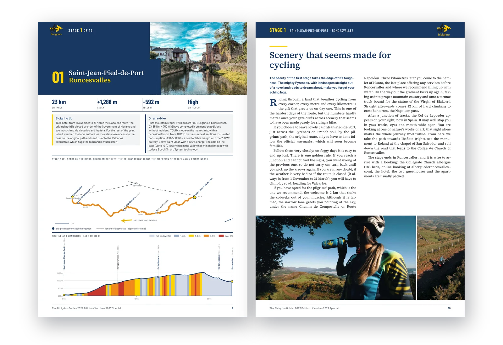
The maths looks logical: the Camino Francés is about 785 km from Saint-Jean-Pied-de-Port, I have 13 days, so that’s around 60 km a day. On paper it works. On the bike, it doesn’t.
Look at three stages from our Bicigrino Guide to the Camino Francés. Each one has a different length for a different reason:
- Saint-Jean-Pied-de-Port – Roncesvalles: 23 km and 1,288 m of climbing. Hard. It’s short because of the climbing. Crossing the Pyrenees is a pure mountain day, and 23 km is more than enough.
- Burgos – Frómista: 65 km and 537 m of climbing. Easy. It’s long because it’s flat. On the Meseta you roll freely and the kilometres go by much faster.
- Sahagún – León: 56 km and 250 m of climbing. Easy. The terrain would allow a much longer day, but it ends in León on purpose: the city deserves a free afternoon to see the cathedral, walk the old town and have a good dinner.
Climbing, terrain and places worth stopping at: those are the three criteria that decide where each stage ends. If you split by distance, your first day is too short, you ride through León without seeing it, and some days in Galicia, with over 1,200 m of climbing packed into 55 or 60 km of ups and downs, feel endless.
The criteria that do work
1. Elevation gain
This is what tires you most. A day with 1,200 m of climbing calls for fewer kilometres than a flat one. Shorten the mountain stages; on flat ones you can go further without paying for it the next day.
2. Terrain
Hard-packed dirt track is not the same as a rocky section or a clay path. After rain, several sections of the Francés become unrideable, such as the climb to Alto del Perdón or the stretch from Azofra to Cirueña. A good plan has the road alternatives ready. The season matters too: the Napoleon Route between Saint-Jean and Roncesvalles is closed from 1 November to 31 March, and you have to climb via Valcarlos instead.
3. Towns worth stopping in
The Camino isn’t only about pedalling. Ending in Burgos or León with a free afternoon to see the cathedral and eat well changes the trip. In our guide we chose some stage ends for exactly that reason, and for others we suggest quieter alternatives, such as Hospital de Órbigo instead of León.
4. Where you’ll sleep with the bike
Not every hotel or hostel accepts bikes or has somewhere to keep them. A stage end without suitable accommodation forces you to keep riding or to sleep where you don’t want to. All the albergues and hotels listed on bicigrino.com accept cyclists and bikes.
5. The battery, if you ride an e-bike
A 750 Wh battery comfortably covers stages of around 80 km with up to about 1,600 m of total climbing. What limits you isn’t the distance but the combination of climbing, assist mode and weight. And you need to charge every night, so your accommodation needs a socket you can use.
6. Your fitness and travel style
Some people want to arrive early and rest; others prefer to stop at every church. Neither is better, but they change the stage split completely.
How to plan the Camino by bike, step by step
- Choose the route. The Francés is the full experience; the Portuguese from Porto, the gentlest for a first time; the Northern route, the toughest and the most spectacular. Compare them in the best Camino de Santiago route to cycle.
- Choose your starting point. By bike, the Compostela requires at least 200 km. On the Francés, the 200 km mark is around Ponferrada; on the Portuguese, starting in Porto is more than enough and starting in Tui is not.
- Decide how many days you have and your start date. In 2027, a Holy Year, May and September will be the busiest months.
- Split the stages by climbing and terrain, not by kilometres, and adjust the stage ends to the towns where you want to stop.
- Book accommodation, starting with the stage ends that have the fewest options.
- Sort out the logistics: how you get to the start, the bike (rented or your own), your luggage and getting back from Santiago. Renting vs bringing your own bike has the real costs.
Example: the Camino Francés in 13 stages
These are the stages in our guide and in the planner, drawn on our own GPS tracks. Notice how the distance changes with the climbing:
| Stage | Route | Distance | Climbing | Difficulty |
|---|---|---|---|---|
| 1 | Saint-Jean-Pied-de-Port – Roncesvalles | 23 km | +1,288 m | Hard |
| 2 | Roncesvalles – Puente la Reina | 67 km | +909 m | Moderate |
| 3 | Puente la Reina – Logroño | 72 km | +1,065 m | Hard |
| 4 | Logroño – Belorado | 73 km | +1,062 m | Hard |
| 5 | Belorado – Burgos | 51 km | +610 m | Moderate |
| 6 | Burgos – Frómista | 65 km | +537 m | Easy |
| 7 | Frómista – Sahagún | 58 km | +285 m | Easy |
| 8 | Sahagún – León | 56 km | +250 m | Easy |
| 9 | León – Rabanal del Camino | 73 km | +640 m | Moderate |
| 10 | Rabanal del Camino – Las Herrerías | 79 km | +993 m | Hard |
| 11 | Las Herrerías – Sarria | 55 km | +1,251 m | Hard |
| 12 | Sarria – Melide | 62 km | +1,204 m | Hard |
| 13 | Melide – Santiago de Compostela | 53 km | +892 m | Moderate |
In total, 785 km and almost 11,000 m of climbing. The stage ends are a suggestion: depending on your fitness, the weather and your bike, your stops may be different. That’s what the planner is for.
Each Camino is planned differently
The Francés example helps explain the criteria, but every route has its own character, and what drives the plan changes a lot from one to another.
| Camino | Usual start | Approx. distance | Character | What drives the plan |
|---|---|---|---|---|
| Francés | Saint-Jean-Pied-de-Port | 785 km | The most complete, with the most services | Climbing and historic cities |
| Portuguese Coastal | Porto | about 270 km | Flat and by the sea | Accommodation, which is scarce |
| Northern | Irún | about 820 km | The most scenic and touristy | Constant ups and downs, and high season |
| Primitivo | Oviedo | just over 300 km | Short, mountainous and demanding | Climbing above all |
| Vía de la Plata | Seville | about 1,000 km | Long, lonely and with little logistics | Water, services and heat |
Portuguese Coastal Camino from Porto
It’s the gentlest Camino for a first time by bike and the one that best shows that not every route is planned the same way. From Porto it’s about 270 km, mostly along the Atlantic, with long stretches of seafront promenade and wooden boardwalks. With little climbing, stages can be longer than on the Francés: our suggested plan does it in five days with hotel accommodation.
| Stage | Route | Distance | What it’s like |
|---|---|---|---|
| 1 | Porto – Esposende | 64 km | Flat, along the Douro and the coast |
| 2 | Esposende – Caminha | 50 km | Flat and parallel to the sea, up to the Minho border |
| 3 | Caminha – Vigo | 61 km | Coast to Baiona, then steep climbs before Vigo |
| 4 | Vigo – Caldas de Reis | 62 km | Galician ups and downs, with Pontevedra halfway |
| 5 | Caldas de Reis – Santiago | 43 km | Ups and downs through villages to the Obradoiro |
Notice how the split again follows the terrain and the places, not the kilometres:
- The first two stages are the easiest, which is why they can be long. Watch out leaving Porto: by the cathedral, the arrows for the Central and the Coastal routes both start, and they’re easy to mix up.
- The second ends in Caminha on purpose. The next day you cross the Minho by boat to A Guarda, and its timetable shapes the stage, so it’s best to sleep there and check the times in advance.
- The third changes character: it’s coast as far as Baiona, but before Vigo come steep climbs and a busy urban approach. That’s why it pays to sleep near the Camino, without crossing the whole city.
- In Galicia the ups and downs begin. From Vigo to Santiago the profile is constantly rolling; you’ll cover fewer kilometres a day than the map suggests, and Pontevedra is worth a stop.
What shapes the plan most isn’t climbing but accommodation: there’s far less of it than on the Francés, and many hotels in central Porto have nowhere to keep a bike. Book your accommodation before you fix the stages. If you rent with us, we hand over the bike at a partner bike shop in Porto. And remember the Compostela: from Porto you easily cover the 200 km, but from Tui or Vigo you don’t.
Using the planner on the Portuguese Camino: choose the Portuguese Coastal Camino, set Porto as your start (or wherever you begin), the days you have and your bike. The plan splits the stages taking into account the flat start and the Galician ups and downs, and you can set Caminha or any other town as a compulsory stop. On the road, your phone guides you on the track where it’s easiest to get lost: leaving Porto, the paths before Vigo and the way into the city.
Northern Camino (Camino del Norte)
About 820 km from Irún along the Bay of Biscay, through San Sebastián, Bilbao, Santander and Gijón. It’s the most spectacular route and also the most touristy: beaches, holiday towns and cities worth stopping in. Services are frequent, but in summer accommodation fills up and prices rise, so book further ahead than on other routes. By bike it’s tough because of the constant coastal ups and downs: few long climbs, but many short ones that add up to a lot of climbing without looking like much on the map. Planning by kilometres fails here even more than on the Francés. It joins the Francés in Arzúa for the final stretch.
Camino Primitivo
Just over 300 km from Oviedo: the shortest of the major Caminos and the most mountainous. Cycling stages rarely go beyond 50 or 60 km, because the climbing adds up very quickly: between Pola de Allande and A Fonsagrada you climb over 2,000 m in a single day. Much of the surface is stony track, so it calls for a mountain bike or an e-MTB. On the Hospitales section, a high-mountain variant very exposed to wind and fog, the sensible choice by bike is the official route through Pola de Allande. It joins the Francés in Melide.
Vía de la Plata
About 1,000 km from Seville, depending on the variant you take into Galicia. It’s a long, lonely Camino, pure bike touring, with far less logistics than the others: there are sections, especially between Seville and Salamanca, where you won’t find a village with services for many kilometres. Here the stages aren’t decided by climbing alone, but by where there’s water, where you can eat and which accommodation is open. Check the next day’s stage before going to bed and avoid the hottest months in Andalusia and Extremadura. We don’t know of any company that carries luggage between stages either, so you ride with panniers all the way. At Bicigrino we also rent bikes for the Vía de la Plata.
The Bicigrino planner: prepare it at home, follow it on your phone
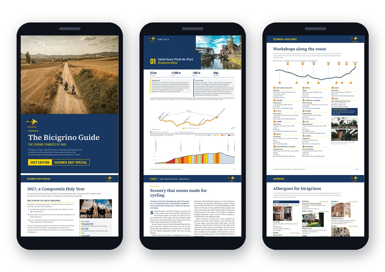
The Camino bike route planner is free and splits the stages using the criteria in this article, not by dividing kilometres. It currently covers the Camino Francés and the Portuguese Camino; the Northern, the Primitivo and the Vía de la Plata are the next routes to be added.
At home, on your computer:
- Choose the route, start and finish, the days you have, your fitness and travel style (direct, balanced or leisurely).
- Set compulsory stops, like that town where you want to spend the night.
- Tell it your bike: MTB, gravel or e-bike. With an e-bike, the plan calculates how much battery you’ll have at each stage end and warns you if one falls short.
- Get each stage with distance, climbing, maximum gradient, estimated riding time and the tricky sections with their alternative. A switch routes everything on tarmac, for gravel bikes or muddy days.
- Save your plan, share it or export it as PDF, GPX or KML.
If you have questions while planning, ask Estela, Bicigrino’s planning assistant. She helps you choose the route, split the stages, know what to expect on each section and what to do when you reach Santiago. She’s free, needs no sign-up, is open to everyone and answers 24 hours a day.
On the road, on your phone: one button sends the same plan to your phone, which becomes your GPS. Live navigation on the Bicigrino track, offline maps for areas without coverage, accommodation and bike shops on the map, repair tutorials and an SOS button always at hand.
The Bicigrino Guide: the Camino Francés as a free PDF
If you’re riding the Francés, download the Bicigrino Guide 2027. It’s 67 pages with the 13 stages, their maps and profiles, the points that need care, road alternatives, 14 partner bike shops and accommodation that accepts cyclists. It’s free, with no sign-up, and shares stages and distances with the planner: what you read at home is what you’ll see on your phone later.
Common mistakes when planning the Camino by bike
- Splitting by kilometres instead of by climbing and terrain.
- Leaving no margin: a rainy day, a breakdown or simply tired legs. If you can, keep a spare day.
- Starting in Sarria or Tui with the Compostela in mind: by bike you don’t reach 200 km.
- Ending a stage where there’s no bike-friendly accommodation, especially in May, September and in a Holy Year.
- Forgetting the return: what you’ll do with the bike when you reach Santiago.
- On an e-bike, not planning the charging: you need a socket every night.
If you rent with Bicigrino
We deliver a Camino-ready bike, with panniers and rack, at a bike shop at your starting point, and we collect it in Santiago. With your booking you also get Jacobo, our on-route technical support, active 24/7: punctures, battery, mechanical issues or route changes, from the start all the way to Santiago. If you’d like help fitting your stages together, get in touch.
Frequently asked questions
How many kilometres a day do you cycle on the Camino de Santiago?
It depends more on the climbing and terrain than on distance. On the Camino Francés, the stages in our guide range from 23 km, on the Pyrenees climb, to 79 km. Mountain stages are shorter and flat ones, like those on the Meseta, are longer.
How many days does it take to cycle the Camino Francés?
Our guide splits it into 13 stages from Saint-Jean-Pied-de-Port to Santiago, about 785 km. Fitter riders or e-bikes can do it in fewer days, and with a more relaxed style, in more. The planner adjusts the split to the days you have.
What is the most common mistake when planning the Camino by bike?
Dividing the total distance by the days available. A 23 km stage with 1,288 m of climbing is harder than a 65 km stage across the Meseta. Split by climbing, terrain and stage ends with suitable accommodation.
Where do I need to start to get the Compostela by bike?
You need to cover at least 200 km. On the Camino Francés, the 200 km mark is around Ponferrada. On the Portuguese Camino, starting in Porto is more than enough; starting in Tui is not.
Does planning change depending on the Camino?
Yes. On the Francés, climbing and the towns where you stop drive the plan; on the almost flat Portuguese Coastal Camino, it’s accommodation, which is scarce; on the Northern, the constant ups and downs and the high season; on the Primitivo, climbing above all; and on the long, lonely Vía de la Plata, water, services and heat.
Is there an app to plan the Camino de Santiago by bike?
Yes. The Bicigrino planner (planificador.bicigrino.mobi) is free, splits the stages by climbing, terrain and travel style, and works as a GPS with offline maps on your phone. It currently covers the Camino Francés and the Portuguese Camino.
Is there someone who can help me plan the Camino by bike?
Yes. Estela, Bicigrino’s planning assistant, helps you for free and without sign-up to choose the route, split the stages and know what to expect on each section. She’s available 24 hours a day. If you rent with Bicigrino, you also get Jacobo, 24/7 on-route technical support.
How do I plan the stages on an e-bike?
Take the battery into account as well as the climbing: a 750 Wh battery comfortably covers stages of around 80 km with up to about 1,600 m of total climbing. The planner calculates how much charge you’ll have at each stage end and warns you if one falls short.
Is there a free guide to the Camino Francés by bike?
Yes, Bicigrino’s Bicigrino Guide 2027: 67 pages in PDF with the 13 stages, maps, profiles, bike shops and accommodation for cyclists. It’s a free download with no sign-up.
How far ahead should I plan the Camino in 2027?
As early as you can. 2027 is a Holy Year and the Camino will be busy, especially in May and September. Ideally have your dates, stages, bike and accommodation booked several months ahead.


